|
|
||
|
*SkunkBayWeather Blog/Photography - Click Here* |
Northern Lights Cam and Time Lapse
|
About SBW |
|
|
Hansville, Washington - Current Conditions
Updated: 10:45pm on 7/25/26 (Updates Every 1 Minute) |
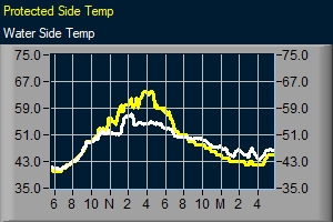
| Temperature | Water Side | Protected Side | Diff. | Wind | Rainfall |
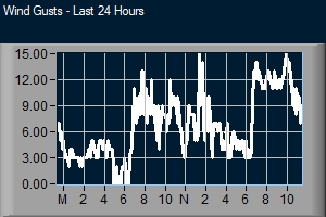
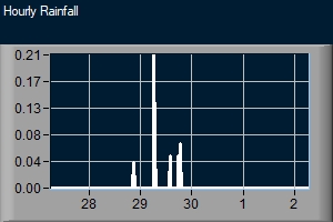
| Current Temp: | 64.3 ° ....feels like 64.3 ° | 64.0° | Current Wind: 0mph / SE | Today's Rainfall: 0.00 in | |
| Current Conditions Metric: | Current Wind: | Today's Rainfall: | |||
| Yesterday @10:45pm | 58.3 | 60.0 | Current Gust: 0mph / kt SE | Hourly Rainfall: 0.00 in | |
| Today's High: | 74.8° @ 1:49pm | 77.0° @ 1:41pm | 10 Minute Average: 0mph / | Monthly Rainfall: 0.48 in | |
| Yesterday's High: | 62.7° @ 3:06pm | 73.0° @ 2:30pm | Today's High Gust: 30mph / @ 4:10pm | Annual Rainfall: 12.45 in | |
| Today's Low: | 56.1° @ 1:41am | 57.0° @ 1:01am | Yesterday's High Gust: 18mph / @ 3:56pm | Yesterday's Rainfall: | |
| Yesterday's Low: | 57.0° @ 11:57pm | 58.0° @ 4:04am | Beaufort Scale*: | Days Without Rainfall: |
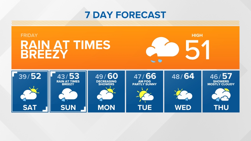
| Solar / Lunar | Barometer | KOMO 7-Day | KING 7-Day | KIRO 7-Day |
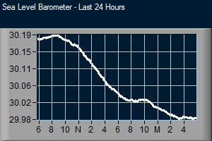
| Sunrise: 5:40am | Current Reading: 29.94 in / (Steady) |

|
|

|
| Sunset: 8:56pm | Hourly Rate: 0.007 | |||
| Moon Percent: 85% | Today's Low: 29.83 in / @ 12:00am | |||
| Moon Rise: 6:54pm | Today's High: 29.94 in / @ 10:30pm | |||
| Moon Set: 1:30am | This Year Low: 29.25 in / on 1/3/26 | |||
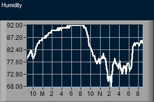
| Humidity / Dew Point | In. to Mb Conversion Chart | |||
| Current: 82% / 58.7° | Current Impact On Tides = | |||
| High: 97% @ 2:02am / 61.5° @ 1:38pm | ||||
| Low: 62% @ 1:47pm / 55.0 ° @ 1:41am |
| NWS Forecast | Hansville Tides |
|
|
|
|
|
|
|
|
| Animated Satellite | Coastal Radar | Puget Sound Radar | National Satellite/Radar |

|

|

|

|
| Local Sponsor | Marine Traffic - Click Here For Vessel Schedule | Local Sponsor |

|

|

|

|

|

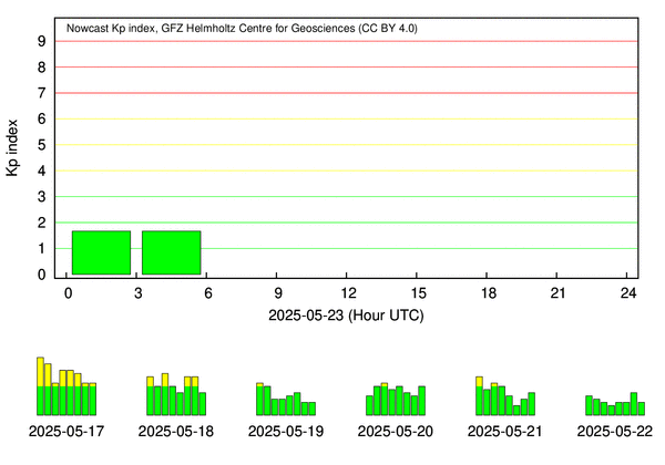
| Clear Sky Chart / KP Index History |
|
***** Click Here For 3 Day Aurora Forecast ***** |

|
|
|
|
||

|

|

|
|
| ||
|
|
||